 | |||||||||||||

ABSTRACTS THEME ONE - The impact of J.G.Granö and Ed. Kant in scientific history
Estonia's Ecological Network - form J.G.Granö and Edg. Kant to current applications
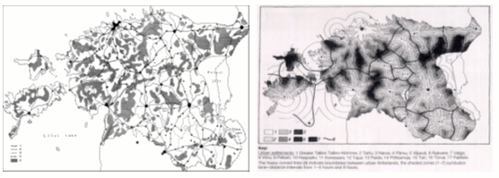
The roots of the idea of the ecological network in Estonia can be found in the works of J.G. Granö (1922, 1929), and E. Kant (1935). Granö's first classification of Estonian landscapes, based on the combination of 3 and 4 landscape element groups show some coincidence with the main axes of the ecological network in the current sense. Kant was the first who implemented the central place theory in explaining the spatial economic relations on a country level. His monograph "Bevölkerung und Lebensraum Estlands" (1935) presented several outcomes of this application in Estonia. It included the hierarchical spatial structure of the country, based on several order flows and influence fields considered simultaneously and the map of less populated areas in Estonia, both of which resemble the current ecological network schemes. The Kant's map on polycentric isochrones of time-distance to Estonian cities (Kant, 1934) was generated by using the same logic as modern ecological network schemes consider the human-caused disturbances (Fig. 1). In reverse circumstances, the polycentric isochrones method can be used for analyzing the migration of biota or recognizing the areas with high nature protection value and biodiversity level (Fig. 2).
References
Granö, J.G. 1922. Eesti maastikuüksused. [Landscape units of Estonia]. Loodus 2 (4-5), 105-123, 194-214, 257-281. The distribution of population is one of the most basic factors for many investigations in geography. Therefore different maps of population are very popular in thematic mapping. However, the methods usually applied (cartograms, random dot density) depict proportions of population between administrative units, are quite sensitive to the methods of data classification and do not describe the actual location of people. An alternative method (absolute dot density) tries to transmit the real pattern of settlements, as an ideal - location of every person. In his last publication E.Kant (1970) gives an overview of history of dot density maps and shows the fuzzi roots of these maps in the first half of XIX century. The first important contribution in Estonia made A.Tammekann (1929). Among others, also E.Kant himself used the absolute dot density for detailed population mapping in urban areas. Census mapping today rests on GIS and geocoding. The technology per se could allow allocating every single person in the geographic space but this potentiality is limited by law (of data privacy protection) and often by several conceptual restrictions. What we are aiming to map? Postal addresses of people? Or their real estates? Working places? Perhaps, the probability to meet the certain number of persons (per time per area) at a given place? In the latter case the question of minimal allowable area arises: precision of GIS permits us to fix location differences of people inside of their living houses (e.g. in left side of bedroom where a couch is) but should we? How to find a reasonable limit? A classic method to avoid the described above difficulties is to use continuous fields of influence calculated on the base of discrete distribution of people. The population potential is one of the most preferred integral indexes in order to take into account the distribution of population as a factor for a certain process. Similarly to the other field-based indexes, also the population potential is subject to interpolation and depends on used techniques and applied parameters. For clear interpretation the units of measure and conditions of interpolation should be fixed. Both population density and population potential are macro-concepts. Their use at local and/or microscale introduces conceptual and technical (mapping) difficulties, which require additional adjustment (e.g. population potential inside and outside of populated area).
In the proposed presentation, besides the overview of the question, several cases of computer-based population mapping made in Estonia, mainly in large scale, are demonstrated and their limitations discussed.
Due to increasing potentialities of GIS to create 3D, 3.5D, and 4D models of processes the conceptual basement for "distribution of population" needs elaboration in order to avoid beautiful meaningless results.
Scientific and academic research take place in particular contexts of physical and social space. Following this one can claim that knowledge is socially and spatially situated. This is evident in the discipline of Geography that is by its (geographical) focus always tied to particular contexts. However, knowledge is traveling with scientists and academic scholars between different places. Traveling, e.g. embodied acquiring of knowledge, also influences on the viewpoints of scholars. Thus, Geography is socio-spatially embodied, maybe more than any other discipline. In this paper I address the theory of situated knowledge and traveling theory by studying the professional career of the internationally most recognized Estonian geographer Edgar Kant (1902-1978). The intellectual development of Kant has been earlier studied by Ann Buttimer (1999, Edgar Kant and the modernist turn in Swedish geography). She illustrates the interplay of contextual circumstances and the connections between cognitive style, vocational preference, and the societal relevance of Kant's geography. The interest in this paper to illustrate the socio-spatial context of Estonian academic geography in the early 20th century and to discuss what kind of geographer Kant became, how and why. Especial focus in this paper is on the detailed study of the development of Urban Geography in the early 20th century and the contribution of Kant into the development of modern Urban Geography.
Kant's life is tightly connected to the development of Estonian State. In the works of Kant, Estonia and Estonian nation-state are continuously present despite his extensive traveling abroad and international contacts or his interest on local and regional approach. Estonia is both the object and the outcome of academic studies of Edgar Kant.
Baltoskandia was an important concept in Edgar Kant´s understanding of the Baltic Sea Area. The first chapter of his thesis discusses the position of Estonia in the Baltoskandian context. Kant understood Baltoskandia as a regional concept, with physical as well as socio-cultural connotations. The aim of this paper is to examine how Kant used this concept and to discuss its usefulness for describing the post-1991 Baltic reality. The recently emerging patterns of integration in the Baltic Sea Area are of special interest for this discussion.
|