|
Jörg Pohlan INTRODUCTION During the first years of the transformation process, economic policy in the Central and Eastern European Countries (CEEC) was oriented mainly towards macro-economic interests. In this process, the growing economic disparities between regions, which were already discernible early on, hardly received any attention. By now this divergence of individual regions turns out to be one of the most serious transformation problems in the CEECs. While some agglomerations have registered a more dynamic growth than many western European regions, especially the rural areas are having difficulties to surmount the obstacles involved in the transition towards a free-market economy. (Haarbeck and Boger 1997, p. 200ff; Krädtke et al. 1997, p. 31, 43ff). Transformation as well as the development processes of the CEEC have led to a drastic decline in the number of jobs, especially in the agrarian sector. Between 1990 and 1995 alone, the economically active population in the agrarian sector decreased by more than 1.14 million (-10.8 %; Latvia -17,000 or -7.8 %). This decrease particularly affects the rural areas, as their economic structure is heavily formed by agriculture. For example, in 1995 22 % of all employment in the CEECs (Latvia: 16.9 %) was still in this sector. In addition, rural areas are often characterised by lower incomes and insufficient infrastructure (EC 1997a, p. 27). As a consequence, severe population losses can be observed in the rural areas of many of the CEECs. While between 1993 and 1996 there was a slight decrease in the total population of the ten CEECs of about 0.6 million (-0.6 %), the number of the urban population increased by about 1.2 million (1.8 %) and the rural areas lost more than 1.7 million inhabitants (-4.4 %). Particularly small-distance migration (e.g. rural-urban) within the national borders (internal migration) is regarded as an important indicator of regional disparities (Schätzel 1996, p. 99ff; Hoffmann-Nowotny 1995, p. 1069ff). Especially in remote rural areas, migration, which is caused by disadvantageous conditions, can lead to an unwelcome decrease in population. Such migration processes mostly take place in a socially selective manner, meaning that particularly the younger and better educated population leaves the remote rural areas. This again worsens the chances for development of the affected regions. Choosing the example of Latvia, the main objective of the study is to identify different types (clusters) of rural areas, each characterised by similar structures and problems. In this context, it had to be considered that the 'rural area' is not one homogenous category. Within 'the rural area' different areas with extremely diversified structures and corresponding unequal chances for development can be identified. Thus a classification of rural areas on the basis of the administrative units of districts (rajoni) was carried out, using different socio-economic and demographic indicators. Each of the identified clusters would need a specific scientific and/or political-planning approach. The paper therefore attempts a) to distinguish rural areas to capture systematic inequalities of socio-economic and demographic structures as well as differences in migration processes in the different sections of territories in Latvia and b) to identify essential spatial-structural determinants which may influence the scale of internal migration as well as other components of rise or decrease of population. The results shall lead to recommendations for target-oriented regional-political measures.
The following section will provide some background information
about the regional structure as well as policy measures in Latvia.
Section three describes and justifies the methodologies used for
the analyses of the main spatial dimensions, and for the classification
of the different types of rural areas respectively; the selection
of indicators is also explained there. The empirical results are
presented in section four, followed by a summary and some conclusions
derived from the study. 2.1 The territorial structure Historically Latvia was subdivided into four regions (Vidzeme, Kurzeme [Courland], Zemgale and Latgale), each characterised by specific ethnic and economic peculiarities. However, this is not taken into account looking at the actual territorial subdivision. At the moment the Latvian administration is subdivided into about 594 local authorities on two levels: a) 26 districts (rajoni) and 7 republic cities, b) 70 cities and towns and 491 rural communities (pagasti). On both levels the administration is directly elected. The central task of the districts is to co-ordinate the measures of the communities during the planning and execution of their responsibilities. In addition they fulfil important responsibilities that are delegated from the central government. Those responsibilities are
The local authorities appear to enjoy a reasonable degree of autonomy,
particularly in financial matters. Grants from central government
are negotiated with each local authority. A major debate is currently
taking place in Latvia concerning a number of issues relating
to local autonomy: amalgamation of communities (more than 400
of them have less than 2000 inhabitants); method of electing the
regional councils; redefinition of the allocation of resources
between central and local governments; incorporation of local
administrators in the national civil service; control of local
finance. (EC 1997c, p. 16f). Although Latvia is a relatively small country, there are considerable differences between regions. These regional disparities are mainly evident in the concentration of industry and unemployment. As a rule, the south-east is less developed than the central regions. Urban structures mainly exist in the capital city Riga, which is the biggest city (816,000 inhabitants in 1997) in the Baltic states. (Ibid., p. 27 and 62). Matters of regional development clearly must be seen as particularly important in Latvia. "During the fifty years of Soviet occupation in Latvia, certain economic sectors were developed under the auspices of the centralised planning system without any economic justification and despite the fact that Latvia had neither the necessary production factors, nor a market for the goods that were produced. This led to the creation of an artificial and deformed territorial structure for the economy; the most important consequences of this are the following:
As a result of the territorial deformation mentioned above, about one third of the entire population (2.48 million inhabitants in 1997) lives in the city of Riga alone. In addition, an excessive concentration of production, social infrastructure as well as scientific potential has occurred in the district of Riga. In 1996 the capital city accounted for 52 % of the industrial output, and 56 % of all capital investments were effected in Riga. The unemployment rate in this city (3.6 %) is half the national average (7.2 %). In addition, there are severe disparities between the other (rural) areas of Latvia, which may be illustrated using three indicators. While unemployment in the Saldus district is 3.6 %, it is 27.8 % in Rezeknes. Revenues from income tax per capita vary from 20.5 lats in Rezeknes to 72 lats in Rigas. The monthly wages and salaries per employed person range from 61 lats in Ludza to 98 lats in the Rigas district. 2.3 The objectives of regional policy and its implementation In economic policy, the important objectives are economic growth, stability and justice (Schätzl 1994, S. 20ff.). In terms of regional policy those objectives can be realised by:
In their assessment of Latvia in the context of a future membership of the EU "Agenda 2000 - Commission Opinion on Latvia's Application for Membership of the European Union", the European Commission summarises four main problems of the country (1997c, p. 63):
Issues of regional development have become especially important in recent years, with the establishment of the market economy. Market forces have led to a polarisation of different regions in the country. If regional policy instruments were not applied, the differences between economically stronger and weaker regions would not only be preserved, but might in fact increase. This is because the economically stronger regions have more favourable conditions for investment and thus development, as they generally have better infrastructures, qualified labour, access to manifold services, etc. (Vaidere and Vanags 1997, pp. 1-4). Therefore, since 1996 the government has devoted specific attention to regional economic development: "conceptual documents describing regional economic development policy, as well as the specification of regions that need special support, were elaborated." (Ibid., p. 2). Regional policy is implemented under the "Regional Policy development guidelines", ratified by the Council of Ministers in 1995. Also, a new law on regional development was passed in 1997. Furthermore, identification criteria for support areas have been developed. The disadvantaged regions identified shall get financial assistance as of this year. In the Regional Development Act it is clearly formulated that regional development policy shall be an integral part of the national development policy. In addition, guidelines on national land use should be established for the whole country. (EC 1997c, p. 63). Latvia's regional development initiatives are implemented through sectoral ministries. While the Ministry of Environment and Regional Development deals primarily with spatial planning, the Ministry of Economy handles regional policy. A Regional Development Council, uniting representatives from all concerned ministries, participates in the drafting, co-ordination and implementation of regional development initiatives. (Ibid.)
However, Latvia's regional policy expenditure is limited. The
state as well as the local governments have limited budget resources,
which means that the range of assistance is also restricted (Vaidere
and Vanags 1997, p. 6). Hence, for the purpose of realising the
objectives of regional policy effectively, it is especially important
to analyse the socio-economic and demographic structures of the
rural areas. The classification shall help to find adequate target-oriented
policy measures for the different types of rural areas. 3.1 Methodological aspects of the classification of rural areas As a first step in the analysis of regional structures it is necessary to differentiate between urban and rural areas. Secondly, the definition of „rural area" as well as its classification into different types are central aspects for the evaluation of its characteristics, the competitive advantages and disadvantages, as well as the resulting need for action in spatially relevant planning and policy. For analytical purposes the OECD distinguishes rural areas into three groups, using population density as an indicator (1996, p. 98; von Meyer 1996):
The threshold value of the population density of a community for being categorised as rural is defined as 150 inhabitants per km². Using this classification of rural areas in Latvia, all of the 26 districts can be classed as significantly or predominantly rural areas. However, these categories contain no information about the socio-economic and demographic situation of the respective rural area. In the context of this investigation, the main thesis is that 'the rural area' is not one homogenous category. Within this 'rural area', very diversified structured types of regions with different chances for development can be specified (Maier and Weber 1995, p. 590). For this purpose the concept of deductive-empirical analysis was chosen among the different approaches of the regional sciences for the classification of areas. This cause-oriented method is especially suited for the objectives of this investigation, which are:
The districts were chosen as investigation units mainly for the reason of data availability and quality. It would have been more adequate and thus desirable for a problem-oriented analysis not to take administrative units but areas defined by socio-economic interactions, for example labour market regions (Eltges 1993). However, no data are available yet for regions that are thus defined. In recent years, both quantity and quality of data at the administrative level of districts in Latvia have improved to an extent which makes an analysis possible using the methods applied here. And finally, if the country joins the EU, the method may be interesting for the purpose of defining regions deserving special support. Recently the European Commission suggested that, following the reform of the structural policy of the EU for the period 2000-2006, nations should be given the opportunity to identify deserving rural regions (new objective 2, former objective 5b) at NUTS 3 level (district level), using their own methods and indicators, both of which will be evaluated by the EU (EC 1998a; 1998b, p. 9). For the determination of the socio-economic structures and the formation of spatial types - in addition to the insufficient differentiation in the official statistics between urban and rural areas - a multivariate classification of rural areas at the district level on the basis of different socio-economic and demographic data was carried out. For this purpose the statistical methods factor analysis and cluster analysis will be applied. A multivariate approach seemed to be especially preferable to a classification on the basis of single indicators, as in Latvia some of the most important data, for example the 'gross domestic product', is not yet available for the district level. Thus a complex factor gives more reliable information than 'second-best-indicators' like for example industrial output in lats. Cluster analysis is used for the purpose of classification of spatial units, and thus presents itself for the formation of spatial types. Before using this method it is advantageous to carry out a factor analysis with the intention of 'filtering' the variables. On the basis of the extracted factors, cluster analysis is then carried out. This procedure offers three advantages:
The next step of the study will be a description of the current development of the size of population in the different areas of Latvia. In addition, the influence of the types of rural areas identified, as well as of the factors identified and variables selected as determinants of migration and of the natural reproduction of a population will be analysed. As methods to examine the significance of the effects of the determinants on the dependent variables, the correlation analysis, regression analysis as well as variance analysis were used. 3.2 Selection of indicators The selection of indicators is very sensitive, as it determines to a large extent the results of factor analysis. During the selection of data, a large number of restrictions became apparent. The main constraint was the availability of certain variables. As already mentioned above, there is no data, such as for example the gross domestic product or the number of employees by branches, available at the district level. Also, many of the indicators were available as reliable and comparable data only for the years 1995 and 1996. For this reason the analysis was restricted to structural data, and no dynamic processes were included, with the exception of the development of the size of the population.
In addition, many data in the context of economic activities were
not usable due to missing values for some of the districts. Thus
only a relatively small sample of the desirable data (see for
example OECD 1994) could be obtained. Most of the data were derived
from the official statistical sources (Central Statistical Bureau
of Latvia 1997a, 1997b, 1998).
For methodological reasons, different tests were conducted, which finally reduced the data set to 18 variables that could be used for factor analysis (see Table 1). These variables are describing mainly the fields of economic performance and socio-demographic structures, as well as locational factors such as infrastructure, settlement structure or distance to Riga. Four of these variables need to be explained in some more detail, as they were not directly obtained from the official statistical publications. The variable 'Distance to Riga' (DISTRIG97) was derived using a map of Latvia and computing the distance via road from the main city of the respective district to Riga. In Latvia, Riga is the central market, and transport costs to the capital city may thus play an important role for the economic situation of the respective district. The 'Agrarian conditions' (AGRPOT96) were computed as yield per ha of cereals and pulses, potatoes, fodder roots, hay, each computed as 'cereal-yield-figures' and finally added up. This indicator should provide information about the agrarian conditions of the respective district. The 'Share of population living in rural communities' (POPRUR97) was computed by subtracting the population of all of those cities and towns in a district that have a population density of more than 100 inhabitants per km² from the total population; the remaining rural population is then expressed as a percentage of the total district population. And finally the 'Cities and towns per 1000 km² of district area' (CITANT97) was computed as an indicator of centrality. Access to the cities means access to infrastructure, education, services etc., and also plays an important role as a locational factor and thus for development potentials.
For testing the significance of the effect of the spatial structures
via variance analysis and regression analysis, six indicators
are used as dependent variables. These indicators describe migration
as well as the natural reproduction of the population in the districts
(see Table 2 and section 4.2).
1 With the exception of „pop9197" each of the dependent variables was computed as the average value for the years 1995 and 1996
Five of the dependent variables are computed as a relative indicator
(per 1000 inhabitants) and as the average value for the years
1995 and 1996 to avoid outliers. As already mentioned, especially
internal net migration is seen as an important indicator of regional
disparities (Schätzl 1996, p. 99ff; Hoffmann-Nowotny 1995,
p. 1069ff). The natural increase per 1000 inhabitants was
selected as an additional indicator of regional disparities (BfLR
1995, p. 28, see also section 4.2). In Latvia also the decreasing
natural reproduction of the population is an important factor
for the severe population losses in some areas. (Central Statistical
Bureau of Latvia 1997b, p. 8ff). 4.1 Spatial structures in Latvia 4.1.1 Dimensions of the spatial structure Using principal component analysis, three factors were extracted, which together account for 74 % of the variance in the set of 18 variables. These factors show different correlations with the original variables. The correlations between the variables and the components are known as the component loadings. They are interpreted in exactly the same way as product moment correlation coefficients, so that the squares of their values indicate the proportion of the variance in the individual variable which can be associated with the component. Thus the factor loading may range between plus 1 and minus 1. A high positive (negative) factor loading means that high values of the relevant original variable in the respective districts correspond with high (low) values of the factors in the administrative units. Hence the level of the component loading shows which variables determine the interpretation of the respective factor. The results of the principal component analysis are given in Table 3.
The first component accounts for 37 % and thus the
largest share of the variance in the set of selected variables.
High loading variables (more than +/-0.6) are data which describe
unemployment, income and demographic structure of the population,
the economic performance of a rural district, as well as its distance
to the capital city Riga. Therefore this component is interpreted
as a "socio-economic condition". Rural districts
with high factor values have correspondingly positive socio-economic
conditions, which are composed by the variables described above.
This means such districts are characterised by relatively low
unemployment and high income among their populations; they have
a large share of young people, while the percentage of the population
past working age is low; the agrarian conditions as well as industrial
output and trade turnover are above average; and these administrative
units are in relative proximity to Riga. Conversely, rural districts
with negative values have a corresponding negative structure.
Medium positive correlations (0.4 - 0.6) can also be observed
with population density and education. Two administrative units
with exceptionally high values (more than 1 standard deviation
above average) are Saldus and Rigas, located in the western and
central parts of Latvia. The rural districts with correspondingly
low values are Daugavpils, Rezekne, Preilu, Balvu, Ludza and Kraslava
- all of them located in the periphery of the eastern part of
Latvia.
a Method: Principal Component Analysis; Rotation: Varimax. b Fur the reason of clarity only loadings more than +/-0.4 are reproduced. c The Eigenvalue represents the sum of the squared component loadings and indicates the total variance accounted for by the respective component. d The percentage of variance accounted for appreciates the relative importance of the eigenvalue, relating it to the total variance in the correlation matrix. The second component extracted accounts for 23 % of the variance. High loading variables with a negative correlation are the share of population living in rural communities, and also, although with a positive correlation, the density of physicians per inhabitants; the number of smaller towns and cities per district (area); the retail trade turnover; and the share of the population with a higher level of education. Here medium positive correlations can be observed with the population density, the number of enterprises per inhabitant, and the income. This component is interpreted as "centrality". The higher the factor value of the respective district, the higher its (relative) centrality - and vice versa. Rural districts with exceptionally high values (more than 1 standard deviation above average) are Rigas, Valmieras and Ogres. The rural areas whose centrality is exceptionally low are Rezeknes, Jelgavas and Ventspils. And finally, the third component accounts for 14.7 % of the variance in the set of variables. The data with the highest positive correlation is the density of roads, followed by the density of post offices and population density. A medium negative correlation was identified with the distance to Riga. This component is interpreted as "physical infrastructure". Exceptionally low factor values were identified in Aluksne as well as in Talsu, Kuldigas and Ventspils. The best conditions in terms of the component "physical infrastructure" can be found in the Central-Latvian rural area around Riga (Jelgavas, Rigas, Dobles, Ogres, Bauskas), as well as in the south-eastern part in Daugavpils. 4.1.2 Classification of rural areas The aim of the classification is to group the rural districts19 into categories comprising similar administrative units, and thus to divide dissimilar districts into different categories. For this distinction of regional types via cluster analysis, the Ward-method was used. Amalgamating two clusters, this method aims at minimising the sum of distances of the individual cases within a cluster to the mean of the cluster. The three principal components identified in the previous section were chosen as variables for the cluster analysis (see also section 3.1).The best result for the purpose of interpretation was the identification of six types of rural areas. Figure 1 illustrates the different types of rural areas in Latvia. For the characterisation of each of the clusters, in addition to the factor values, the original variables were also used; both the mean values in the different clusters and their standard deviation were considered (see Table A-1 in the appendix). Cluster 1 is the largest cluster, comprising 14 districts. As a rule, their socio-economic performance is on a level with the national average. In most of the districts, industrial output as well as retail trade turnover are slightly above the mean. Centrality is generally above average, the provision with infrastructure slightly below the mean. The districts belonging to this cluster are located in the western, as well as in the northern and central parts of Latvia. Most of the original variables do not deviate too much from the national average.
Clusters 2 and 4 comprise the remote rural districts, which are
mostly disadvantaged. In both clusters socio-economic conditions
are far below the average of all rural districts. However, the
values for factors 2 and 3 differ considerably between the two
groups of districts. Centrality is around the mean in cluster
2 (Balvu, Ludzas, Kraslava and Preilu), but far below it in cluster
4 (Rezeknes and Daugavpils). These latter two rural districts
surround the republic cities Rezekne and Daugavpils respectively,
where central facilities are concentrated. The value for provision
with infrastructure is mean in cluster 2. In cluster 4, it is
comparatively satisfactory, which is mainly due to the existence
of roads and railway tracks for transit to St. Petersburg, the
Russian Federation (Moscow) and Belarus. The surrounding districts
offer an attractive landscape, while the two republic cities have
the necessary infrastructure. Thus there are good conditions for
tourism, both in the cities and the districts. The districts in
both clusters are located in the eastern part of Latvia. These
regions, which are close to or adjoining the Russian border, are
generally characterised by poor natural conditions for both agriculture
and industry, as they are hilly.
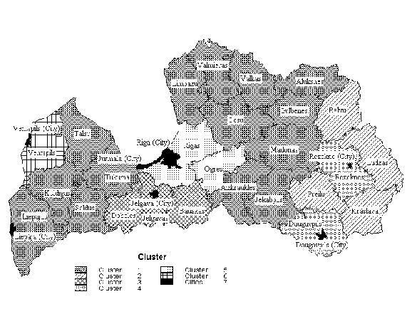 Figure 1. The Spatial Structure of Latvia 1996 Cluster 3 consists of three districts (Dobeles, Jelgavas and Bauskas), which are located in the central south, close to or adjoining the Lithuanian border, not very far from the capital Riga. Although centrality in this rural region is far below average, it is characterised by a fairly good socio-economic situation and quite a positive provision with physical infrastructure (main transit from Riga to Lithuania). Compared with the other rural areas, agrarian conditions are especially good in this region (see also Boruks 1992, p. 127). Cluster 5 is formed by two districts (Rigas and Ogres), one surrounding, the other close to the capital Riga. Most of the values of the socio-economic indicators are far above the average, as are centrality and the provision with infrastructure. These districts clearly profit to a large extent from their proximity to the Riga agglomeration, and may be described as suburbanised areas. In addition, they seem to perform very well in all three sectors (as far as the chosen indicators are able to give reliable information), which provides them with additional potentials for independent development.
Cluster 6 includes only one single district (Ventspils). This
is a special case: a remote rural area located on the western
coast and surrounding the republic city Ventspils, which has an
extremely positive economic performance. As many of the inhabitants
of the rural district work in the urban centre, income tax revenues
are above average, while the economic situation is fairly poor
on the whole. For example, the industrial output per inhabitant
is less than one third of the national average. In addition, the
district Ventspils is characterised by extreme rurality, i.e.
population density is about one quarter of the mean of all rural
districts. Furthermore, there is no community with a population
density of more than 100 inhabitants per km² in the district.
Also, the provision with infrastructure is extremely poor. This
district must be seen as being largely dependent on the republic
city Ventspils. Being located on the Baltic sea, this rural district
may have a good potential for tourism, but suffers from a severe
lack of infrastructure.
Figure 2 presents the demographic trends in Latvia since 1960,
both the overall development and a subdivision into urban and
rural areas. Between 1960 and the late 1980s there was a permanent
growth of the total population. This growth took place mainly
in the urban areas, while the population in the rural areas decreased
permanently until the early 1980s and then stabilised. After independence
the pattern changed. Since 1991 the total population has been
decreasing, with the greatest speed in urban areas. However, the
number of inhabitants in rural areas has also started to decrease
again. Between 1990 and 1997 the total population decreased by
190,600 (-7.1 %), while the losses were -140,400 (-7.6 %)
in urban areas and -53,200 or (-6.5 %) in rural areas.
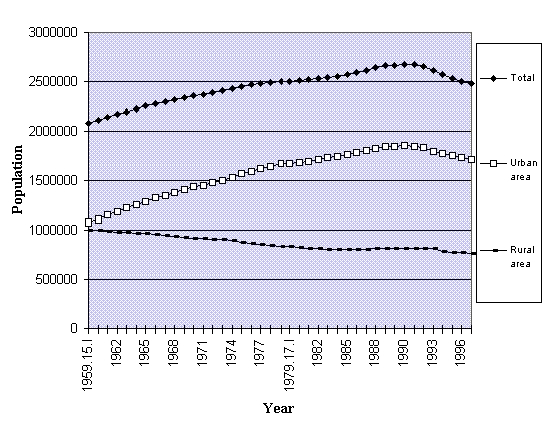 Figure 2. Population in Latvia between 1960 and 1997 The factors of population change can be subdivided into two main components, net migration and natural increase. Since 1991 both factors have become negative simultaneously. The negative total net migration was to a large extent caused by international out-migration. The main destination for the majority of emigrants was the Russian Federation, followed by the Ukraine and Belarus. These three nationalities alone account for 39.4 % of the total population and for 88.3 % of net migration in 1996 (Central Statistical Bureau of Latvia 1997b, pp. 34, 141, 142). As the concentration of people of the three nationalities mentioned above was high in the cities, they are affected disproportionately by international out-migration. To give an example, 95.8 % of the net migration of Russians has affected the cities and towns. This may be the main explanation for the rapid population losses in the cities, and especially in Riga. In addition, since 1990 the second important factor for the demographic development, natural increase, has become negative for the first time in decades. Here the main reason is seen in worsening living conditions, as well as in uncertain future prospects (Federal Statistical Office 1994, p. 26). The net internal migration as an indicator of regional disparities was already introduced in section 3.2.
The patterns of recent demographic development in the different
types of regions in Latvia can be seen in Table 4. In order to
identify the significance of the differences between the individual
rural clusters, analysis of variance (ANOVA) was carried out.
The results are shown in the same table.
a With the exception of „population 1991-97 in %" the indicators were computed as average value for 1995 and 1996 The findings indicate a significant impact of the spatial structure on all of the selected indicators with the exception of national emigration. Between 1991 and 1997 all types of regions (including the republic cities) were characterised by population losses. However, the extent of the population decline was most dramatic in the cities (Riga lost about 10 % of its population) and in the rural areas in clusters 6, 3 and 2. Looking at the total net migration per 1000 inhabitants in 1995/96, the losses in Riga and in cluster 3 are still disproportionately high. The situation in the other cities has stabilised in relation to the mean value. Clusters 5 and especially 4 are those with positive net migration values, caused by high positive internal migration. The stabilisation in the 6 republic cities (without Riga) and the increase of population in clusters 4 and 5 are to a large extent caused by the high level of national immigration, while the severe losses in cluster 3 are caused by national immigration which is far below the national average. There are no great differences between national emigration figures for clusters 1 to 5. However, they are exceptionally high in cluster 6 (Ventspils), where immigration is on a similarly high level. National emigration is especially low in the republic cities. Although there are significant differences between the different types of rural and urban regions, the results clearly do not reveal a pattern of migration that could be explained by regional disparities alone. For example, cluster 4 was identified as one of the disadvantaged remote rural areas and has the highest positive value of net internal migration. Looking at national emigration, the values are slightly above average in clusters 2 and 4 (both disadvantaged rural clusters), and exceptionally high in cluster 6 (again, a disadvantaged rural district). However, these differences are first of all not statistically significant, and secondly they are compensated or even overcompensated by national immigration. Looking at natural increase, the values are negative in all different types of rural areas, as well as in the cities. However, the values are exceptionally negative in the two clusters in the eastern periphery, which were classified as being especially disadvantaged economically. As two main factors affecting migration, Layard et al. (1992, p. 21) name the following: comparative wage levels, both actual and expected, as well as comparative employment rates. Thus the next step was to establish whether significant correlations exist between the selected indicators of migration and natural increase and a) the main spatial dimensions (factors) identified in section 4.1, and b) the wage and unemployment levels. Only three variables were identified which have a significant correlation with just two of the dependent variables. The highest correlation (r = 0.89) was identified between the principal component 1, which was interpreted as "socio-economic conditions", and the natural increase. 79.2 % of the variance of the natural increase is explained by socio-economic conditions (R² = 0.792). Since factor analysis was carried out only with the rural districts, the results are restricted to the rural areas. Here socio-economic conditions clearly have a statistically significant influence on natural increase. Relatively bad socio-economic conditions lead to lower natural reproduction of the population than relatively good conditions.
Also, significant correlations could be identified between the
salary and wage levels of the population and national emigration
(r = -0.58), as well as between the unemployment rate and natural
increase (r = -0.68). The income of the population accounts for
34.5 % of the variance (R² = 0.345) in national emigration,
while unemployment explains 46.3 % of the variance in the
natural increase.
The regression equations illustrate to what extent the independent
variables affect the dependent variables. As expected, low-income
districts have higher national emigration figures than districts
with higher wages and salaries, while higher unemployment rates
cause lower natural reproduction rates. The main objective of this study was to determine socio-economic structures and to distinguish different types of rural areas. The results of the analysis show severe disparities between urban and rural areas, as well as between different types of rural areas. Using the multivariate approach of factor analysis at the district level, three main spatial structural dimensions could be identified, which were interpreted as "socio-economic conditions", "centrality" and "physical infrastructure". On the basis of the factor scores, cluster analysis was then carried out in order to achieve a classification of rural areas. As a result, six different types of rural areas were distinguished, each of them requiring specific treatment in terms of regional policies. One cluster (1) was labelled as "medium rural area" consisting of 14 districts. Three clusters (2, 4, and 6) were "remote rural districts" which clearly are most in need of development; they are, however, characterised by different conditions in terms of centrality and provision of infrastructure. And two clusters are formed by "advantaged districts". One of them (3) consists of districts with very good agrarian conditions and fairly good socio-economic conditions in general, the other (5) consists of the "suburbanised area" with exceptionally positive values for most of the indicators. In addition, the development of the population was analysed in the different spatial types. Since 1990, severe population losses have taken place in Latvia, both in rural and urban areas. Looking at the recent pattern of migration in the rural areas, significant differences exist between the different types of rural areas. However, no significant influence of the identified factors on net internal migration could be established. Here, clearly determinants other than those represented by the set of variables used for the analysis have a substantial influence. Instead of "internal migration" the "natural increase" turned out to vary systematically in the different rural areas, being mostly negative in the remote disadvantaged rural districts in the eastern region of Latvia. In addition, a highly significant impact of the factor "socio-economic conditions" on natural increase, mainly determined by the level of unemployment, was identified. Also, a significant (negative) correlation could be recognised between the income of the population and national emigration. There is clearly a need for deeper analysis at the level of smaller-scale administrative units to obtain information for realistic regional planning. However, for that purpose the data base will have to be extended. Even at the district level, important indicators like, for example, GDP or employment by branch, are still missing. In addition, interviews with experts, as well as with immigrants and emigrants about their motives, may provide important information for policy measures.
The method for classification applied here would seem to be well-suited
for the purpose of identifying the similarities and differences
between structures and processes in rural areas in comparative
studies of other CEECs. BAHRENBERG, G.; GIESE, E.; NIPPER, J. (1992): Statistische Methoden in der Geographie, Band 2: Multivariate Statistik. Teubner, Stuttgart. (BFLR) BUNDESFORSCHUNGSANSTALT FÜR LANDESKUNDE UND RAUMORDNUNG (Ed.) (1995): Laufende Raumbeobachtung - Aktuelle Daten zur Entwicklung der Städte, Kreise und Gemeinden 1992/93, Materialien zur Raumentwicklung, H. 67, Bonn. BORUKS, A. (1982): Zemes Izmantosanas Efektivitate. Zinatne, Riga. CENTRAL STATISTICAL BUREAU OF LATVIA (1997a): Administrative Districts and Major Cities of Latvia. Statistical Yearbook. Riga. CENTRAL STATISTICAL BUREAU OF LATVIA (1997b): Demographic Yearbook of Latvia. Riga. CENTRAL STATISTICAL BUREAU OF LATVIA (1998): Towns and Civil Parishes in the Administrative Districts of Latvia. A Collection of Statistical Data. Riga. DZENE, I. (1997): Privatisierung und Umstrukturierung der landwirtschaftlichen Unternehmen in Lettland. Unpublished M.A.-dissertation (Magisterarbeit), Landwirtschaftliche Fakultät, IAMO, Martin-Luther-Universität Halle Wittenberg. EC EUROPEAN COMMISSION (1997a): AGENDA2000 - Band I: Eine stärkere und erweiterte Union. Brüssel, DOC/97/6 (Internet). EC EUROPEAN COMMISSION (1997b): AGENDA2000 - Band II: Mitteilung: Intensivierung der Heranführungsstrategie. Brüssel, DOC/97/7 (Internet). EC EUROPEAN COMMISSION (1997c): AGENDA2000 - Stellungnahme der Kommission zum Antrag Lettlands auf Beitritt zur Europäischen Union. Brüssel, DOC/97/7 (Internet). EC EUROPEAN COMMISSION (1998a): „AGENDA2000" - Vorschläge der Kommission. Brüssel, Fact Sheets der DG VI (Internet). EC EUROPEAN COMMISSION (1998b): Vorschläge zur Verordnung der Strukturfonds 2000-2006. Brüssel (Draft). ELTGES, M. (1993): Die Abgrenzung ländlicher Räume im Rahmen der Regionalpolitik der Europäischen Gemeinschaften. Materialien zur Raumentwicklung, H. 54, Bundesforschungsanstalt für Landeskunde und Raumordnung, Bonn. FEDERAL STATISTICAL OFFICE (1994): Länderbericht Lettland 1993. Metzler-Poeschel, Stuttgart. HAARBECK, P./ BOGER, S. (1997): Europäische Politik für die Entwicklung ländlicher Räume. ASA, Bonn. (= unpublished paper) HENKEL, G. (1995): Der Ländliche Raum - Gegenwart und Wandlungsprozesse seit dem 19. Jahrhundert in Deutschland. Teubner, Stuttgart. HOLM, K. (1976): Die Faktorenanalyse - ihre Anwendung auf Fragebatterien. In: HOLM, K.: (ed).: Die Befragung. 3. München (Francke), pp.11-268) HYDRO AGRI DÜLMEN GmbH (Ed.)(1993): Faustzahlen für Landwirtschaft und Gartenbau. Verlagsunion Agrar. JANA SETA (Ed.) (1993): Latvia Road Map. Latvia. JOHNSTON, R. J. (1978): Multivariate Statistical Analysis in Geography. London, New York. KRÄDTKE, S.; HEEG, S.; STEIN, R. (1997): Regionen im Umbruch - Probleme der Regionalentwicklung an den Grenzen zwischen „Ost" und „West". Campus, Frankfurt a.M., New York. LAYARD, Richard; BLANCHARD, Olivier; DORNBUSCH, Rüdiger; KRUGMAN, Paul (1992): East-West migration: the alternatives, MIT-Press, Cambridge, Mass. MAIER, J./ WEBER, W. (1995): Ländliche Räume. In: ARL AKADEMIE FÜR RAUMFORSCHUNG UND LANDESPLANUNG (Ed.): Handwörterbuch der Raumordnung, ARL, Hannover, p. 589-596. OECD (1993): Welche Zukunft für unsere ländlichen Räume? Eine Politik der ländlichen Entwicklung. Paris. OECD (1994): Creating Rural Indicators for Shaping Territorial Policy. Paris. OECD (1996): Better Policies for Rural Development. Paris. SAKTINA, D. (1997): Lauku vide un Latvijas lauku iezivotajs taja: regionaleo atskiribu prieksrocibas un trukumi. Mgazine of the research publications of LVAEI, No. 9. SAKTINA, D.; MIGLAVS, A. (1996): Latvijas lauku attistibas analize un atskiribu veidojoso apstaklu vertejums. (Research Projekt for the Ministry of Environmental Protection and Regional Development). SCHÄTZL, L. (1994): Wirtschaftsgeographie 3: Politik. Paderborn u.a. (UTB 1383). SCHÄTZL, L. (1996): Wirtschaftsgeographie 1: Theorie. Paderborn u.a. (UTB 782). WOLLMANN, H. (1994): Systemwandel und Städtebau in Mittel- und Osteuropa, Birkhäuser, Basel, Boston, Berlin. (= Stadtforschung aktuell, Bd. 46). VAIDERE, I./ VANAGS, E. (1997): The Promotion of Regional Economic Development. (Internet)
VON MEYER, H. (1996): OECD-Indikatoren zur ländlichen
Entwicklung - Konzeption und erste Ergebnisse. in: BFLR BUNDESFORSCHUNGSANSTALT
FÜR LANDESKUNDE UND RAUMORDNUNG (Ed.): Ländliche
Räume - Rural Areas - Espaces Rurales - Ländliche Entwicklung
im internationalen Vergleich, Informationen zur Raumentwicklung,
H. 11/12, Heft 11/12. 1996, p. 729-743.
Table A-1. Mean and standard deviation of the factors and the indicators used for the analysis in the different types of regions
| ||||||||||||||||||||||||||||||||||||||||||||||||||||||||||||||||||||||||||||||||||||||||||||||||||||||||||||||||||||||||||||||||||||||||||||||||||||||||||||||||||||||||||||||||||||||||||||||||||||||||||||||||||||||||||||||||||||||||||||||||||||||||||||||||||||||||||||||||||||||||||||||||||||||||||||||||||||||||||||||||||||||||||||||||||||||||||||||||||||||||||||||||||||||||||||||||||||||||||||||||||||||||||||||||||||||||||||||||||||||||||||||||||||||||||||||||||||||||||||||||||||||||||||||||||||||||||||||||||||||||||||||||||||||||||||||||||||||||||||||||||||||||||||||||||||||||||||||||||||||||||||||||||||||||||||||||||||||||||||||||||||||||||||||||||||||||||||||||||||||||||||||||||||||||||||||||||||||||||||||||||||||||||||||||||||||||||