|
Siamak Baradaran, Lars Lundqvist 1. Introduction The Baltic Sea region has been the scene of many drastic changes during the last decade: - the dismantling of the "iron curtain" between east and west from 1989 leading to unification of Germany and transition to market economies in Eastern Europe; - the extension of the single European market to the EFTA countries in 1993; - the entrance of Sweden and Finland into the European Union in 1995; and, - the negotiations on further enlargement of the European Union with east European countries in 1998; All these changes have reduced the political and economical barriers between the various parts of the Baltic Sea region. With increasing interactions the infrastructure networks have been upgraded, first in terms of air connections and ferry routes. Trade patterns have been characterised by drastic reorientations and rapid growth. Tourism and cultural exchanges have expanded. Hence, the Baltic Sea region has developed into a very dynamic region with many more or less simultaneous socio-economic factors triggering rapid changes. However, there are big differences in accessibility and interaction intensities within the region: the accessibilities of east Baltic regions are very low at the outset and the growth in cross Baltic trade between eastern and western economies occurs from very low levels. The region can be seen as a full-scale laboratory offering unique challenges for theoretical and empirical research. Building a comprehensive geographical information system (GIS) of the Baltic Sea region would open up a wide potential for monitoring and analyses of spatial interaction, accessibility, urban and regional development and interdependencies between spatial transitions and infrastructural changes. This paper presents ongoing work on studying infrastructure and mobility patterns in the Baltic Sea region within a GIS environment. The project is supported by the National Swedish Road Administration as part of its work on future scenarios for the Swedish road transportation system. Earlier work has focused on infrastructure and accessibility (Lundqvist 1995), dynamics of trade and mobility (Persson, Lundqvist and Berglund 1997) and on current trends in economic integration (Lundqvist and Persson 1998). These studies have been of an aggregate character with trade between countries, number of direct air connections between major airports, number of ferry passengers etc. Within the GIS environment outlined in this paper and further developed in the project, integrated analyses of more detailed and complete mobility patterns on the one hand and more disaggregate infrastructure networks will become possible and feasible. The aim and research strategy is further elaborated in Sections 2 and 3.
In Section 4 the completed road system is described as an example
of a fullfledged set of infrastructure networks to be developed
within the project. Section 5 presents some early examples of
accessibility case studies performed on the road network of the
Baltic sea region. In Section 6 we present the available data
sources for estimating mobility patterns of goods and people.
The dynamics of trade and mobility is illustrated with available
aggregate data and some projections of future trade growth are
reported. Finally, in Section 7 we summarise the future work on
synthesising networks and mobility patterns in the beginning of
the 1990s, on modelling these patterns and on using the system
for analyses of the implications of future mobility patterns for
the Swedish transport system and for analyses of transportation
flows in border regions. 2. Aim and research strategy The main aim of the project is to provide a high quality basis for judgements on how the rapid and superimposed change processes in the Baltic Sea region will affect the transport flows of goods and people in general and the utilisation of the Swedish road system in particular. The analysis should handle both supply driven (e.g. infrastructure investments, transeuropean networks) and demand driven change processes (e.g. economic development, trade reorientations and growth of tourism). A system view of economic development, infrastructure and transport patterns in northern Europe is adopted and seen as a necessary component of the research strategy. In order to create maximum flexibility for various kinds of aggregate and disaggregate studies of the Baltic Sea region, an early decision was taken to compile maximally disaggregate data on infrastructure and mobility within a geographical information system (GIS). Since transportation is the focal point of the project, a transportation oriented GIS with some analytical capabilties was selected: TransCAD. Data on land and coast lines, national and regional borders, population and other activities and networks for roads, rail and ferry lines have been collected and integrated within the GIS. Shortsea shipping and air connections will most probably be added later. The major challenge is to estimate mobility patterns of goods and people on a disaggregate level. As for trade flows, detailed intranational origin-destination matrices are available for part of the region, some interregional flows across the Swedish borders have been projected and international trade statistics provides an aggregate source of data. As for personal mobility, detailed intranational origin-destination matrices are available for part of the region together with travel surveys for long distance trips and link counts on ferry routes and travel flows at airports. Disaggregate data on population, employmet and transport generation and attraction will be used in order to estimate disaggregate transportation patterns. Based on the geographical information on infrastructure and mobility outlined above, a rich menue of possible and feasible analytical options will be open. The infrastructure networks and the data on activity volumes may be used for various studies of "accessibility landscapes"within the Baltic Sea region. The estimated mobility patterns in the beginning of the 90s may be modelled using various representations of remaining barriers. The impacts of removal of such barriers may be analysed. Based on scenarios for the economic development of the Baltic Sea region, the models of mobility patterns may be used for projections of future transport flows.The future use of the Swedish road system is of particular interest, taking domestic traffic, international road transport flows with origin or destination in Sweden and international transit flows into account. The system may be used for studies of the impacts of transport investments (including transeuropean network investments and national projects). Studies of border regions may be of special interest in many cases. For the first stage of the project the following three types of analyses have been given the highest priority: - accessibility studies; - trade patterns and goods flows: estimation of base year OD matrix and computation of link flows in the networks, simple future projections; and, - the Öresund region: studies of transport flows before the completion of the Öresund bridge and alternative future projections.
During the second stage of the project (1999-2000), the aim is
to add information on shortsea shipping and air connections, to
improve the modelling of mobility patterns for goods and people
and to study future transportation flows with regard to intermodality
and alternative scenarios. 3. A geographic information system for the Baltic Sea region In recent years, the Baltic Sea region has been subject to wide spread interest. Many research and development projects have focused on spatial planning issues (VASAB 2010 1994), infrastructure developments and North-European integration (Hedegaard and Lindström 1998). However, to our knowledge no earlier attempt has been made to compile a detailed geographic information system (GIS) as a resource for analysing spatial planning and infrastructure development issues. This project is aiming to contribute to such an investment. A GIS has obvious advantages in spatial representation and data base management, for spatial analysis and for spatial visualisation. As an example, among the Baltic Sea countries there are several transportation equilibrium models in use. Many of these models are using transportation networks represented by conventional straight links between the nodes. Computationally, this is very efficient during the route assignment procedure but the network suffers on the other hand from a poor spatial representation of its components and their attributes. Consequently, such a database would only allow limited analysing capabilities, e.g. in terms of environmental impact assessments. Our ambition in this project goes beyond the conventional network representation and the standard GIS analytical tools. We want to combine a detailed geographic representation with state-of-the-art analytical capabilities in the field of infrastructure and mobilty modelling.
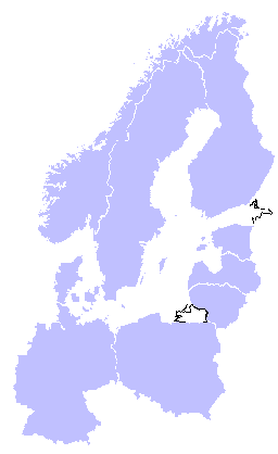 Figure 1:The Baltic Sea countries (except west Russian regions) The national transportation models applied in the Baltic Sea region are not harmonised in terms of network detail or timing of the data bases. The ambitions of our project have to take these circumstances into account. Setting up a GIS on infrastructure and mobility requires extensive data collection and data integration (e.g. networks for road, railroad, air and sea transports, transport flows, population statistics, etc.) demanding major research efforts. In addition, the geographic extension of the study region (outlined in Figure 1 except the western part of Russia) results in complications, since corresponding data from different countries have diverse origins (e.g. data from different, years, qualities, projections, etc.). We decided to use the GIS software TransCad, which is a vector based geographical information system with integrated procedures for network analysis and spatial modelling. The program has extensive built-in subprograms and import and export capabilities which simplifies the data handling routines.
The road and railroad networks are brought into the TransCAD database
by integration of earlier networks implemented in national level
models in the Nordic countries (Sweden, Finland, Norway and Denmark)
with a European infrastructure database (the IRPUD-network of
the Institute of Spatial Planning; University of Dortmund; see
Wegener and Spiekermann (1996)) and some other spatial data extracted
from international data bases like Digital Chart of the World.
The population data for major cities in the region are collected
from national yearly statistics which are matched to their respective
spatial projections. Land-use and land-coverage data are accessible
in this project through relevant GIS databases. The use of a GIS
based analysing system with ability to spread data into layers
allows us to request any kind of spatial data, e.g. for future
environmental impact studies. Transportation demand related to
origin-destination combinations are conveniently stored and processed
in matrix form. 4. Example of infrastructure network: system of roads The road network constructed for this project, consists of network data from different countries. The relevant countries shown in Figure 1 are Sweden, Finland, Estonia, Latvia, Lithuania, Poland, Germany, Denmark and Norway. In addition, the western regions of Russia are included. The available data can be divided into three major categories:
When the desired networks had been compiled, the networks from different countries were joined together by special border links. These links have no length and only enables border passages. The use of border links allows us to control the international flows, and the border links can be associated by time delay attributes to represent the real life of many border crossings.
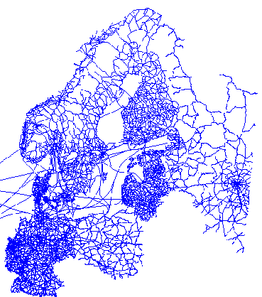 Figure 2: The Baltic Sea road network In the Baltic Sea region many transports take place by ferries or boats. There are special ferry and boat links available in the IRPUD road networks which provide alternative transport options between some countries.
Figure 2 represents the main road network for the Baltic Sea
region. The network contains more than 65,000 links. All the links
have certain attributes as length, link type, belongingness to
the strategic network or not, volume/delay function and some country
specific attributes (e.g. Euro-way number, etc.). This network
could be combined to the IRPUD network for the rest of Europe,
if needed. In that way we are enabled to use other data sources
within EU, since the IRPUD networks are adopted within the GISCO
spatial reference data base, providing base data for EU countries.
5. Sample case studies of accessibility In the field of transportation and regional and urban economics, especially in the case of trip distribution and location analysis, the concept of accessibility is well known. There are several definitions of accessibility. As described by Hansen (1959), "accessibility is the potential of opportunities for interaction" or by Weibull (1980), "accessibility is a measure of an individual's freedom to participate in activities in the environment" or more precisely, accessibility is expressed by "attractiveness of a node in a network taking into account the mass of other nodes and the cost to reach those nodes via the network" (Bruinsma and Rietveld 1998). In our project the main focus is on modelling network flows with obvious relations to traffic generation and attraction which is related to accessibility. As we are analysing the transport pattern of persons and freight in the Baltic Sea region, we need to understand the trip generation mechanism behind them. Therefore, we decided to generate different kinds of accessibility measures. These measures help us to understand properties of the Baltic Sea region geography and networks, and are useful for our later estimations of origin-destination matrices. Two types of input data are necessary for measuring the accessibility of a location:
 Figure 3: Accessibility in the Baltic Sea region
One particular kind of accessibility measure can be generated by only focusing on the spatial separation variable (Allen et al. 1993)
In other words, the accessibility of location i is defined as the sum of link costs (sij) from the location i to all other locations j. Figure 3 shows the accessibility of some major cities in the Baltic region based on the above definition. This kind of accessibility measure tends to point out the most central points of a region. However, we should be aware of that the study area is delimited to the Baltic Sea region and that all our accessibility indicators are only related to this system.
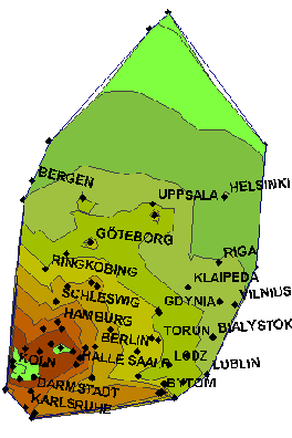 Figure 4: Accessibility in the Baltic Sea region Another accessibility formulation could be obtained by assuming that the accessibility of a node is proportional to the distance dependent interaction intensity of that node to all other nodes (Keeble et al. 1982).
 The masses of the nodes are represented by their population in this case. Figure 4 shows an accessibility map based on the above statement.
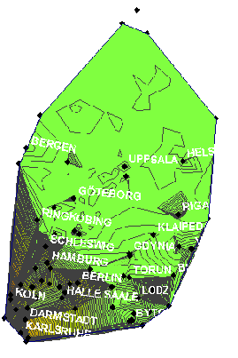 Figure 5: Accessibility in the Baltic Sea region To let the accessibility measure better reflect real life time budgets, one can limit the travel time to some maximum related to the characteristics of the trips. This kind of travel time limitation will however disturb the time-space graph which is originally a continuous function. The accessibility measure will suddenly incresase when another node is coming within the time limit. Figure 5 represents the same accessibility map as Figure 4 but the interactions are limited to below a distance of 700 km. We can note that the accessibilities in northern part of the region are decreased by introducing the distance limit, while in southern parts the accessibility is still high due to the high density of cities in that part of the region. Another kind of accessibility measure could be calculated based on utility theory. If we assume that utility of visiting city i from city j is given by the utility function :
(Vji is observed net utility, vi
is the city related utility and represents the dissutility
per unit transport cost). By assuming that the random term ()
of the utility functions are independent and identically Weibull
distributed, the accessibility measure can be calculated as:
The parmeter should be estimated and an origin-destination
matrix is needed to find a 6. Transport patterns for goods and people For the estimation of origin-destination (OD) matrices of goods and people, data on intranational transport patterns in the beginning of the 1990s have been collected. In the Swedish case also interactions between Swedish regions and aggregate European regions are available. The following data have been acquired:
Obviously the variation in categories of goods, modes and regional subdivisions of the national matrices will require some harmonising efforts before these OD matrices may be used for estimation purposes. The row and column sums of the intranational OD matrices for goods may be taken as proxies for the location of production activities. Such proxies may be employed for regional disaggregation of international trade data. An alternative is to use regional employment data. This method is likely to be pursued for international trade between regions in non-Nordic countries. For interregional trade within these countries data are completely missing. This means that the level of congestion within these countries will be underestimated if observations or projections of link flow counts in these countries can not be acquired.
From earlier research, see Lundqvist and Persson (1998), we know
that Germany has by far the stongest position in intra-Baltic
trade. The next strongest position is held by Sweden and the strongest
single link (both directions) is between Germany and Sweden, see
Figure 6.
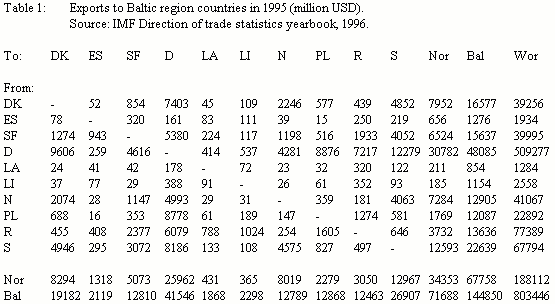
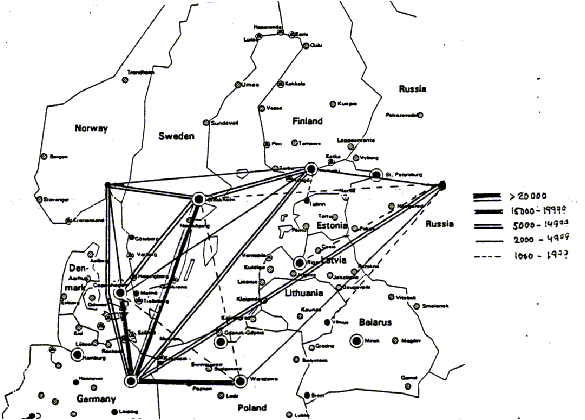 Figure 6: Major trade flows in the Baltic Sea region 1995 (million USD, both directions)
Source: IMF Direction of Trade Statistics, 1996
A more complete report on the trade flows in 1995 is provided
in Table 1. The volume of exports from the Baltic republics and
Poland has more than doubled in three years. Also exports from
Finland and Germany to Baltic region countries have expanded faster
than the average three year growth of about 27 per cent. The trade
data of Table 1 have been used to estimate a gravity type trade
model, where the trade flow is explained by the GDP of the exporting
and importing countries, the distance between the countries and
some dummy variables for trade union memberships and seaborne
transport, see Strömquist and Åberg (1998). The estimated
parameters of the model have then been used in projections of
future trade scenarios. Annual growth rates of about 5-6 per cent
between 1995 and 2015 are foreseen. Other estimates show somewhat
lower growth rates of about 3.5 per cent, see Callsen (1998).
We plan to develop our own model of Baltic trade at a later stage
of the project.
 The pattern of direct air connections in the Baltic Sea region in 1996 is displayed in Figure 7. The pattern shows some similarities with the patten of trade links: the interactions are strong between the Nordic countries and between the Nordic countries and Germany (to some extent via Copenhagen). The total frequency from the Baltic republics is increasing rapidly from low levels. The absolute growth is, however, greater in the western part.
The passenger traffic by sea to/from Sweden is about 4-5 times
higher than the total international air traffic. Passenger traffic
by sea with Denmark is dominating but has been loosing shares
of the total market to interactions with Finland and (to a lesser
extent) with Germany since the 1970s. 7. Plan for future work Work on developing a railway network similar to the road network is in progress. The railway networks for the individual countries have been collected and a network for the whole region will soon be constructed. Accessibility measures (see Section 5) will then be evaluated for the railway system.
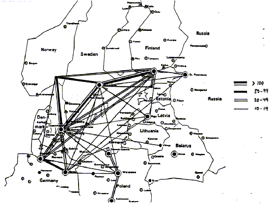
Source: ABC World Airways Guide, February 1996 We aim to complement the road and railway networks by shortsea shipping and air transport as well. This will extend and improve the analysing potential of our GIS database and modelling system for studies of infrastructure and mobility of the Baltic Sea region. The building up of complementary networks will start in second period of this project beginning in January 1999. Another long-term goal of this project is to construct a multimodal network for freight and passenger transports. We are studying the possibilities to convert the constructed networks into a so called multimodal super-network. We are also studying the possibility to synthesise the multimodal network by using the NODUS computer programme developed within the Group on "Transport and Mobility"(GTM) in Mons, Belgium, see Jourquin and Beuthe (1996). Based on the multimodal network we plan to study the potential for intermodality and decisions on combined mode and route choice alternatives and the resulting loading on the infrastructure networks. On the basis of completed networks and estimated interaction patterns in terms of trade and personal mobility during the the first half of the 1990s, we plan to model the relations between infrastructure provision and mobility. More disaggregate trade models could be estimated based on a rich description of transport conditions. Models of personal international (and interregional) travel by different transport modes may similarily be developed. A specific research issue is to study the impact of spatial aggregation on the model results. By varying the level of regional aggregation, we hope to be able to study the robustness of model parameters. This would give us an idea about the suitable level of spatial aggregation in this project or similar research contexts.
The ultimate aim of the project is to provide analyses of future
scenarios for mobility within the Baltic Sea region and their
consequences for the Swedish transport system. In particular the
impacts of future scenarios in terms of link loads in the Swedish
national road system will be of interest. The Öresund region
will be selected as an example of a border region, where detailed
analysis of a number of superimposed regional, interregional,
international and transit flows is needed. Acknowledgement
This paper is reporting on research which is funded by the Swedish
National Road Administration. Data (networks and origin-destination
matrices) have been provided by the Swedish National Road Administration,
the Finnish National Road Administration, the Danish Road Directorate
and the Institute of Transport Economics, Norway. The reference
group of the project has contributed with important advice. Helpful
contacts with Michael Wegener and Klaus Spiekermann, Institute
of Spatial Planning, University of Dortmund, are gratefully acknowledged.
References Allen, W.B., Liu, D. and Singer, S. (1993) "Accessibility measures of U.S. metropolitan areas", Transportation Research, vol 27B, pp. 439-449 Bruinsma, F.R. and Rietveld, P. (1993) "Urban agglomerations in European infrastructure networks", Urban Studies, vol 30, pp. 919-934 Bruinsma, F.R. and Rietveld, P. (1998) "The accessibility of European cities: theoretical framework and comparison of approaches", Environment and Planning A, vol 30, pp. 499-521 Callsen, S. (1998) "Trade potentials in Northern Europe and consequences for traffic flows", in Hedegaard, L. and Lindström, B. (eds): The NEBI Yearbook 1998 - North European and Baltic Sea Integration, Springer-Verlag, Berlin, pp. 73-86 Hansen, W.G. (1959) "How accessibility shapes land use", Journal of the American Institute of Planners, vol 25, pp. 73-76. Hedegaard, L. and Lindström, B. (eds) (1998) The NEBI Yearbook 1998 - North European and Baltic Sea Integration, Springer-Verlag, Berlin Jourquin, B. and Beuthe, M. (1996) "Transportation policy analysis with a geographic information system: the virtual network of freight transportation in Europe", Transportation Research, vol 4C, pp. 359-371 Keeble, D., Owens, P.L. and Thompson, C. (1982) "Regional accessibility and economic potential in the European Community", Regional Studies, vol 16, pp. 419-432 Lundqvist, L. (1995) "Transportation infrastructure and accessibility in the Baltic Rim area", in Lundqvist, L. and Persson, L.O. (eds): Baltic Regions and Baltic Links, The Nordic Institute of Regional Policy Research 1995:2, pp. 132-148 Lundqvist, L. and Persson, L.O. (1998) "Current trends in economic integration", in Hedegaard, L. and Lindström, B. (eds): The NEBI Yearbook 1998 - North European and Baltic Sea Integration, Springer-Verlag, Berlin, pp. 55-71 Persson, L.O., Lundqvist, L. and Berglund, S. (1997) "Dynamics of trade and mobility in the Baltic region", in Owsinski, J.W. and Stepniak, A. (eds): The Nordic-Baltic Europe: Integration Risks, Barriers & Opportunities, The Interfaces Institute, Warsaw, pp. 97-130 Strömquist, U. and Åberg, P. (1998) "Trade and modal change in the Baltic region - Scenarios to 2015", Working Paper, TRITA-IP AR 98-61, Division of Regional Planning, Royal Institute of Technology, Stockholm VASAB 2010 (1994) Vision and Strategies around the Baltic Sea 2010: Towards a Framework for Spatial Development in the Baltic Sea Region, Third Conference of Ministers for Spatial Planning and Development, Tallinn. Wegener, M. and Spiekermann, K. (1996) "The potential of microsimulation for urban models", in Clark, G.(ed.): Microsimulation for Urban and Regional Policy Analysis, European Research in Regional Scince, vol 6, Pion, London, pp. 146-163
Weibull, J.W. (1980) "On the numerical measurement of accessibility",
Environment and planning A, vol 12, pp. 53-67 |